


Select NOAA-NWS Forecast Office Text Products
(Product availability varies with seasons, forecast office, and weather.)
Forecast Discussion for New York City/Upton, NY
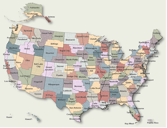
To Select Another NWS Office Click on Map or Choose from List
|
| Select Forecast Office: | Select Product: |
059
FXUS61 KOKX 160957
AFDOKX

Area Forecast Discussion
National Weather Service New York NY
557 AM EDT Thu May 16 2024

.SYNOPSIS...
Low pressure spins south of the area before slowly pulling away
to the southeast this afternoon. Weak high pressure then builds
in from the northeast Thursday night through Friday. High
pressure may remain in place as another frontal system and
potential wave of low pressure approach late weekend. High
pressure then builds in for early next week.

&&

.NEAR TERM /THROUGH TONIGHT/...
Forecast remains generally on track with showers continuing for
Long Island and Southern Connecticut. Otherwise, updated the
temperatures and dew points to reflect the most recent
observations.

Low pressure continues to spin south of Long Island allowing
for continued areas of generally light rain in the area through
the day. As the low begins to pull southeast offshore during
the afternoon, widespread rain should become more showery in
nature and gradually shift south while diminishing in
intensity. Despite this, an additional inch is possible in some
portions of southern Connecticut. Locations to the west may
stay dry much of the day. Winds will remain N/NE through much of
the day at 10-20 mph with localized gusts up to 30 mph. Highs
today will be in the low to middle 60s for much of the area,
though some western areas may rise into the upper 60s, still
5-10 degrees below average.

The low pressure continues to make its progression back
offshore to the southeast tonight, allowing any showers to move
with it. Some low level moisture may allow for some pockets of
drizzle or a stray shower, especially along the coast but
largely the area will remain dry tonight. High pressure noses in
from the northeast. Lows will be in the 50s.

&&

.SHORT TERM /FRIDAY THROUGH SATURDAY NIGHT/...
Surface high pressure slides into the area from the north and
northeast in response to developing shortwave ridging over the
area, as the low pushes further offshore. This will result in
generally dry conditions on Friday with temperatures climbing
back up to seasonable values, despite partly to mostly cloudy
skies.

The next system approaches from the west into Friday night and
early Saturday, bringing with it a low chance for showers
approaching from the west into early Saturday morning. Most
global models show the frontal system slowly weakening as it
approaches the area with high pressure fighting to remain
overhead. A more robust low pressure system looks to develop
well to the southeast and push offshore Saturday into Saturday
night. Though there will remain a low chance of showers for
western areas, the trend in models to suppress the system to
the south has allowed for a drier forecast to take hold. Despite
the main energy shifting south, high pressure will allow for a
persistent NE/E wind over the area, keeping the region cooler
than average through the weekend under mostly cloudy skies.

&&

.LONG TERM /SUNDAY THROUGH WEDNESDAY/...
*Key Points*

*A drier trend in the pattern for the weekend.

*Below normal temperatures to start the period with a gradual
 warm up to near or slightly above normal by mid next week.

By Monday into Tuesday, model divergence continues as the more
progressive EC takes the low to the northeast and out of the region
while the GFS maintains a more cutoff solution and meanders the
surface low off the NC coast. Weak ridging builds in thereafter,
with a shortwave and low pressure system approaching from the west
late Tuesday into Wednesday.

&&

.AVIATION /10Z THURSDAY THROUGH MONDAY/...
Low pressure just south of Long Island early this morning will
initially be stationary before beginning to track slowly south
late this morning. The low will weaken and continue to track
south through tonight, while high pressure builds in from the
north.

Mainly light rain and/or drizzle is expected this morning, then
dissipating in coverage this afternoon. KSWF will be mainly
dry, but could see spotty light rain/drizzle. Looking for a
persistence forecast the next 18-24h with ceilings mainly
MVFR for NYC and the Lower Hudson Valley, and IFR/MVFR for the
eastern terminals.

N-NE winds early this morning will be strongest with G25-30kt
along the coast and 20-25kt elsewhere. Winds will be slow to
diminish through the day.

 ...NY Metro (KEWR/KLGA/KJFK/KTEB) TAF Uncertainty...

Ceilings may vary between IFR and low end MVFR this morning.

OUTLOOK FOR 06Z FRIDAY THROUGH MONDAY...

Friday: VFR.

Saturday and Sunday: Mainly VFR. Chance of MVFR and showers,
mainly Saturday night and Sunday. SE winds G15-20kt on Sunday.

Monday: VFR.

Detailed information, including hourly TAF wind component forecasts,
can be found at: https:/www.weather.gov/zny/n90

&&

.MARINE...
Low pressure south of the area will allow SCA conditions to
persist for all waters today with gusts upwards of 30 kt and
seas on the ocean 7-10 feet. Gusts taper off tonight but seas
remain elevated on the ocean above SCA thresholds through much
of the day on Friday.

Sub SCA conditions are likely thereafter into Monday.

&&

.HYDROLOGY...
An additional 1-2" remain possible in southern Connecticut as a
low pressure system spins south of the area. While no widespread
flooding is expected, poor drainage or nuisance flooding may
occur in any heavier or steadier rainfall this morning.

There are no hydrologic concerns from Thursday afternoon
onward.

&&

.OKX WATCHES/WARNINGS/ADVISORIES...
CT...None.
NY...None.
NJ...None.
MARINE...Small Craft Advisory until 6 PM EDT this evening for ANZ331-
     332-335-338-340-345.
     Small Craft Advisory until 6 PM EDT Friday for ANZ350-353-355.

&&

$$

SYNOPSIS...MW
NEAR TERM...MW
SHORT TERM...MW
LONG TERM...DBR
AVIATION...DW
MARINE...DBR/MW
HYDROLOGY...DBR/MW
|
Previous Forecast Discussions may be found at
NWS New York City/Upton, NY (OKX) Office Forecast Discussions.
(Click 'Previous Version' there to view past versions successively.
Some may differ only in time posted.)
Products Courtesy of NOAA-NWS
NWS Information Parsing Script by Ken True at Saratoga Weather - WFO and Products Scripts by SE Lincoln Weather.
Mapping by Curly at Michiana Weather and by Tom at My Mishawaka Weather.